Starting point

Understand waters and infrastructure better. Substantiate decisions better.

Many tasks in water management, civil protection and the operation of critical infrastructure cannot be solved with a single sensor, one more data portal or a conventional expert report. Measurement data sits in different systems, spatial and temporal gaps remain, and new technology has to fit into existing processes, responsibilities and infrastructure.

e.Ray develops integrated solutions for this. We combine measurements on site with satellite, weather, gauge, infrastructure and specialist data, translate data into an understandable situational picture and create the basis for concrete decisions. In doing so, we consider technical architecture, water-body processes, communication paths, security of supply, measures, operation and financing together from the outset.

Our goal is not more technology in the water body or in the infrastructure, but more knowledge, better decisions and effective measures: Understand waters better. Design resilient infrastructure. Secure communication even during a disruption. Waters in Balance.

Infographic Water-body & resilience network: WAMO measurement stations on a lake and a river, water-level sensors on bridges, weather sensors, radio relay, base station and control centre, GNSS and Earth observation satellites; data fusion in a central platform with real-time monitoring, historical data, analyses, documentation and alerts. Enlarge
Infographic e.Ray · as of August 2026 · in German
Services

Our consulting fields

Monitoring and water quality

Focus area: water quality →

WAMO measurement station on a lake, with the probe under water beneath it

We develop measurement and monitoring concepts for lakes, rivers, retention basins, floodplains and engineered water systems. This includes selecting suitable measured variables, sites, measurement intervals and transmission paths as well as integrating existing sensors and external data sources.

Possible topics include oxygen, temperature and stratification, pH, conductivity, turbidity, redox, nutrients, chlorophyll, organic load or complementary biological methods such as eDNA. Individual measuring points become a robust picture of the condition of the water body – in real time, over longer periods and, if required, across several water bodies.

Typical results

  • Measurement concept
  • Station and sensor design
  • Data architecture
  • Pilot installation
  • Analysis logic
  • Operation and maintenance concept

Water balance, water availability and low water

Focus area: flooding and low water →

SWIM map view of a lake with grid cells and catchment

How much water is available today, how is the situation changing and where do risks arise? We combine local water-level and gauge data with precipitation, evaporation, catchments, runoff paths, satellite observation and historical data.

This creates new foundations for low-water management, irrigation decisions, retention basins, groundwater recharge and the long-term assessment of regional water availability. The focus is not only on individual measuring points but on the interplay within the catchment – from inflow through storage and use to evaporation and discharge.

Typical results

  • Water balance model
  • Analysis of data and monitoring gaps
  • Low-water indicators
  • Scenarios
  • Forecasting approaches
  • Regional water situational picture

Heavy rainfall, flooding and resilient infrastructure

Focus area: communication →

Masthead of a WAMO station with antenna and solar module

Warning and information systems have to work precisely when the power supply, mobile networks or individual measuring points fail. We design energy-self-sufficient and redundant sensor and communication networks for retention basins, water bodies, bridges, critical points, transport routes, energy and utility installations as well as municipal infrastructure.

In a vendor-neutral way, we combine new and existing sensors with suitable communication paths – for example mesh networks, LoRaWAN, mobile networks, microwave links and satellite-based transmission. Resilience Hubs can pool local data, pre-process it and keep it available even during a disruption. Where it makes sense, the infrastructure is used not only for flood events but at the same time for low water, water balance, situational pictures and the regular operation of water bodies and facilities.

Typical results

  • Risk and failure analysis
  • Network and communication architecture
  • Site planning
  • Redundancy concept
  • Alerting logic
  • Pilot network
  • Scaling plan

Critical infrastructure and secure communication

Resilience Hub →

Resilience Hub on the roof of a fire station, with solar module and antenna

Critical infrastructure requires robust data, clear situational pictures and communication paths that continue to work during outages, overload or natural events. We support operators, municipalities, public authorities and utilities in developing resilient monitoring, communication and decision-making structures.

The focus is on capturing critical conditions, assessing dependencies and failure risks, and planning redundant power, data and communication paths. To this end, local sensor networks, edge processing, Resilience Hubs, emergency power concepts, mesh communication, LoRaWAN, mobile networks, microwave links and satellite communication can be combined. Existing control, operating and information systems are integrated wherever possible and complemented by independent situational-picture and warning functions.

We look not only at individual facilities but also at cross-sector dependencies – for example between water, energy, transport, telecommunications, public administration and civil protection. The result is solutions that work efficiently in normal operation and remain capable of acting in a crisis or disruption.

Typical results

  • Criticality and dependency analysis
  • Protection and resilience concept
  • Communication and emergency architecture
  • Failure and restart planning
  • Situational picture
  • Alerting and escalation logic
  • Operation and exercise concept

Connecting data and building water intelligence

Data integration in the dashboard →

SWIM dashboard with map, readings and time series

The value of data arises from connecting it. We bring measurement data together with publicly available and specialist data sources – including state portals and the monitoring networks of the German federal states, LAWA, WasserBLIcK/Wasser-DE, BfG, DWD, EFAS, Copernicus, SWOT, EnMAP, HydroATLAS and HydroSHEDS.

In addition, we integrate operational, facility, energy, transport, weather and communication data where this is required for the situational picture, risk analysis or decision support.

Building on this, we develop data pipelines, maps, time series, automated analyses and decision-oriented applications. Existing specialist and control systems are not replaced but complemented by expert interpretation, spatial context, resilience assessment and a measures perspective. Depending on the task, e.Live, e.Data, e.Maps or e.Wai are used as modules.

Typical results

  • Data source and interface concept
  • Data consolidation
  • Automated reports
  • Water-body and infrastructure explorer
  • Situational picture
  • Analysis models
  • Decision support

Planning measures and demonstrating impact

Focus area: water-body restoration →

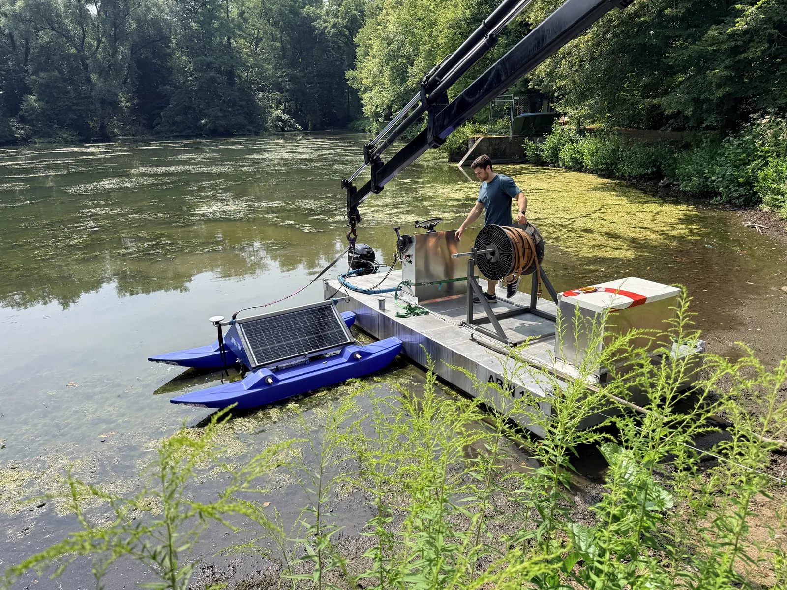
Aeration pontoon with hose reel at the Backhausteich

Measures at water bodies and infrastructure must not only be implemented but also assessed in a traceable way for their impact. We develop baselines, monitoring designs and analyses for renaturation, floodplain development, aeration and oxygen management, nutrient reduction, macrophyte management and further measures to stabilise water bodies.

We likewise assess measures to increase the resilience of critical infrastructure, improve communication paths, reduce failure risks and secure operation in crisis situations.

In doing so, we consider ecological, hydrological, technical and – where relevant – climate-related impacts together. This covers the requirements of the Water Framework Directive as well as new approaches to greenhouse gas monitoring, MRV, risk and resilience indicators. This makes visible what a measure changes, how durable its impact is and where adjustments should be made.

Typical results

  • Initial state and baseline
  • Impact model
  • Monitoring plan
  • Before-and-after comparison
  • Cost-benefit assessment
  • WFD-related assessment
  • Climate, resilience and MRV concept

Innovation projects and new system solutions

Current projects →

Test tank in the e.Ray laboratory

Where no finished product exists for a task yet, we develop a suitable solution together. We translate technical and operational needs into system requirements, examine technical options, build partner structures and test new approaches under real conditions.

This may be an energy-self-sufficient monitoring network, a new type of water-level or warning system, a resilient communication solution, an independent situational picture for critical infrastructure, the combination of satellite and on-site data, an active water-body measure or a new digital analysis service. The starting point is always the specific challenge – not a predefined product.

Typical results

  • Target vision
  • Feasibility study
  • System design
  • Requirements list
  • Prototype
  • Field trial
  • Implementation and financing roadmap
Approach

From the challenge to a working system

  1. Clarify the task and the decision required

    We analyse the water body, the available data, the parties involved, critical dependencies and the decision that is to be taken better in future. The result is a clear objective instead of a mere collection of technology.

  2. Design the solution and the system architecture

    We combine water-body processes, measured variables, sensors, power supply, communication, data sources, security requirements and analysis into a sound overall concept. Existing systems and investments already made are integrated wherever possible.

  3. Pilot and learn in live operation

    New approaches are implemented in a clearly defined pilot area or operational unit. Real operating data and tests under normal, load and fault conditions show early on what works, where gaps remain and how the system has to be adapted.

  4. Assess impact and secure operation

    We define key figures, check data quality, availability and benefit, and develop maintenance, operating, security and responsibility models. This also includes emergency, restart and exercise concepts. In this way a successful trial becomes a solution that can be used permanently.

  5. Scale and transfer

    Proven modules are transferred to further water bodies, municipalities, facilities or regions. For this we develop standards, rollout plans, cost models and – where appropriate – funding or procurement strategies.

Consultation at the e.Ray trade fair stand
Crane placing a WAMO station in the water at the Backhausteich
Collaboration

Research, funding and consortium management

Innovative water and resilience solutions rarely emerge from a single actor. They require knowledge of water bodies, research, technology, implementation partners, infrastructure operators and public users. e.Ray brings these perspectives together and takes on the technical and organisational translation between them.

We support the set-up and management of national and international consortia – from partner structure, roles and work packages through milestones, budget and funding logic to technical integration, testing and the transfer into operation. In doing so, we also take into account requirements for critical infrastructure, information security, availability, emergency preparedness and resilient communication.

Our experience ranges from space and remote sensing through digital water management and municipal demonstration projects to resilient communication and infrastructure solutions and international cooperation.

e.Ray team at the ESA stand

Selected projects

ESA/DLR demonstration project

Combining energy-self-sufficient on-site monitoring, Earth observation and new data-based applications for a better understanding of water bodies, water availability and resilient information structures.

More about the ESA/DLR demonstration project →

IGP SPLASH

Consolidating existing data sources with sensor data, developing new analyses with artificial intelligence, and approaches to WFD reporting, assessment of measures and the verification of climate and greenhouse gas effects.

SWIM and European collaboration

Developing and testing transferable solutions for water-body observation, water intelligence, resilient communication and climate-resilient water management in a European consortium.

More about SWIM →

International water projects

Transferring monitoring, data, communication and measures approaches to international water bodies and reservoirs – together with local partners, science, the public sector and development cooperation.

Discover international projects →

Profile

What sets e.Ray apart as a development partner

Final assembly of a WAMO station in the e.Ray hall
WAMO 220 with buoy in operation on a lake
Dashboard station map with the measurement stations in Mecklenburg-Vorpommern

Thought through from the water body and the infrastructure

We begin with the system, the processes, the dependencies and the decision to be taken – not with an individual product.

Vendor-neutral and open to integration

Our own systems, existing sensors, partner products, control and operating systems as well as public data sources are combined into a suitable architecture.

Proven in live operation and close to implementation

Our concepts are not created at the desk alone. We develop, install and operate systems ourselves under real conditions and also test them under failure and load scenarios.

Energy-self-sufficient and resilient

Communication, power supply and data paths are planned so that solutions can also work at remote sites, with limited infrastructure and in critical situations.

Secure and capable of acting during a disruption

We take into account availability, redundancy, emergency operation, restart and clear responsibilities. This keeps situational pictures and decision bases usable even when individual systems fail.

From the measuring point to the catchment and the overall system

We combine local real-time data with spatial data, remote sensing and models – from the individual water body or facility site to the regional water balance and a cross-sector view of resilience.

Research with a clear application focus

New methods are linked early on with the concrete requirements of public and operational users. The result is outcomes that can continue to be used, operated and scaled after the project.

Who we work for

  • Cities, municipalities, districts and federal states
  • Water associations, water-body maintenance bodies and dam operators
  • Environmental, water and civil protection authorities
  • Operators of critical infrastructure
  • Utilities, infrastructure operators and industry
  • Transport, energy and telecommunications companies
  • Research institutions and universities
  • Nature conservation and environmental organisations
  • Post-mining landscapes and land developers
  • International project and implementation partners

Possible consulting modules

  • Strategy workshop and needs analysis
  • Criticality, risk and dependency analysis
  • Feasibility study and target vision
  • Measurement, data and system concept
  • Site and network planning
  • Communication and redundancy concept
  • Energy-self-sufficient supply and emergency power planning
  • Requirements list and specification of services
  • Pilot planning, installation and field test
  • Failure, emergency and restart planning
  • Cost-benefit and scaling model
  • Funding strategy and consortium building
  • Technical project management and consortium coordination
  • Impact monitoring, reports and decision papers
  • Resilience, security and operating concepts
  • Innovation-oriented and legally compliant procurement concepts
Why we do this

Water is our shared foundation of life.

That is why e.Ray exists. We develop technologies that make water bodies more understandable and support people in dealing with them responsibly.

More about us →

“We are e.Ray – a team that combines research, engineering and drive to understand and protect water bodies and to strengthen habitats. We develop solutions that enable people to take responsibility for their environment. In doing so, we live by what matters to us: openness to different perspectives, fair collaboration and the will to make a difference together.”
Next step

Do you have a water- or infrastructure-related challenge for which no suitable standard solution exists yet?

Then we will develop the right path together – grounded in expertise, open in technology, resilient and geared towards practical implementation from the outset.